
 Travel
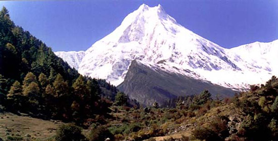
Introduction:
Manaslu was declared a "Conservation Area" in December 1998 by HMG's Ministry of Forest and Soil Conservation under the National Parks and Wildlife Conservation Act of Nepal. It covers an area of 1663 sq. km. The region harbors a mosaic of habitats for 33 species of mammals, 110 species of birds, 11 species of butterflies and 3 species of reptiles. There are approx 2000 species of plants, 11 types of forests and over 50 species on useful plants. The bio-climatic zones vary from sub-tropical to Nival. The altitude rises from a mere 600m. to the summit of Mt. Manaslu (8,163 m), the eighth highest peak in the world.
Climate:
The Manalsu region region from Arughat to Larkhe La (Pass), has six climatic zones : tropical, subtropical, temperate, subalphine, alphine and arctic. The extreme climatic contrasts within the 100km trail between Arughatand Samdo are associated with tremendous differences in elevation, topography and precipitation. The tropical climatezone lies in the low level river basins of the Buri Gandaki, Maryangdi and other rivers, lowland valleys and lower hills below the elevation of 1000m. A subtropicl climatic zone exists between 1000 m and 2000 m where the average summer and winter temperature range between 31 to 34oC and 8 to 13oC respectively.
The temperature climatic zone lies at higher hils above 2000 m and below 3000m. In this zone, summer temperatures range 22 to 25oC, and winter temperatures range -2 to 6oC. Frosts and snowfall are common during winter (January and February). The subalphine climatic zone lies between 3000 and 4000 m where snowfall occurs for about fou to six months (December to May). In this zone, winter is very cold and even in summer the temperature is not high with a mean annual temperature of 6 to 10oC. The alphine zone between 4000m and 5000m is mostly open meadows. The arctic climatic zone lies at elevations above 4500m.
The snow line is at about 5000m. Precipitaiton is in the form of snow and the temperatures drop far below freezing. The monsoon occurs between June and September providing about three-fourths of the total rainfall. The post-monsoon period (October to November) and the winter months (December to February) are usually dry. The average rainfall is around 1900 mm per annum. In general, the southern part of the region remains cloudier and wetter than the upper subalpine areas and alphine areas.
How to get there:
The trek starts from Gorkha, home of the legendary Gorkha soldiers, and follows the meandereing Budhi Gandaki River or the Darundi River before reaching Larke Pass (5106 m.) and crossing over into Manang district of ACAP.
Vegetation:
The vegetation of the area can be divided into three main categories, based mainly on the altitude, viz. Low hill, Middle mountain and High mountain types. Each category has its own types of dominant forests and other associated species. The types of vegetation, however, tend to overlap the adjoining ones at places especially in relation to aspect and micro-climate. While thev forest types are quite distinct, the underlying as well as adjoining flora in different forest types do not vary so sharply.
Ti sis especially true in cases of many NTFPs including medicinal herbs and romatic plants, many of which have a large encountered in different forests types and adjoining vegetation. The presence of 19 types of forests and other forms of dominant vegetation have been recorded from the area.
Source: Department of National Parks and Wildlife Conservation